Beating the Tube by bike
Continuing the discussions on isocrones and their potential benefits to bicycle advocacy, here’s an iscocrone map from the world of walking.

It’s a zone 1 Tube map of London which shows walking times between stations. It’s designed to get commuters out of the Tube a stop or two earlier than usual so they can walkercise to their final destination. The map was created in February by postgraduate students from Central St Martins College of Art and Design.
It would be a great idea to create something similar for cycling times. Mapped against walking, Tube times and car journey times it would be an argument winner. The classic Tube map is brilliant, but in no way spatially accurate, hence the need for the post-grad students to create an isocrone map. Here’s a spatially corrected Tube map.
The walk times on the Tube map look a tad ambitious on some sections, especially if you factor in rush-hour pavement crushes, Japanese tourists and errant, 4WD pushchairs. Cyclists, on the other foot, can predict their route times with a great degree of accuracy.
And cyclists are also big users of GPS devices. So, imagine a website for London which listed genuine travel times between major Tube stations, plotted via handlebar-mounted Garmin devices. A MySQL database skinned by a GPX-uploading front-end could allow users to submit times, which could then be averaged for times of day, weather conditions and so on. This would work for any city but cities with well-known public transit lines - London, Newcastle, New York, Paris – would be the best to plot against.
There are already loads of GPS-friendly mash-up sites (but nothing quite like the idea above). The best include GPX and Google Earth export and snap-to-route capabilities. Here’s a bunch of them:
Motion Based (a Garmin-owned site)
RouteYou
Bikely (a Future/BikeRadar site)
Trip Tracker
RunningMap
BikeRoute Toaster
MapMyRide
VeloRoutes
Routeslip
CyclistNexus
Toporoute
GMAP-pedometer
GMAP
AllSportGPS
RouteYou.com has a nifty little YouTube video of how it works:
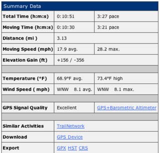
I use a Garmin Edge on my bike. Here’s a route I completed earlier this year.

I loaded it to MotionBased.com. It contains detailed info such as weather conditions, elevation, average speed and so on.

Mac users will love the GPS-uploading software from Ascent. This runs with the same GPX data as MotionBased.com but does it in a graphically superior way. The animation feature is especially cute, although you have to add your own eye-in-the-sky traffic chopper SFX:


